Good afternoon, dear car enthusiasts!
In this material we will look in detail at how to determine the coverage area of prohibitory road signs 3.16, 3.20, 3.22, 3.24, 3.26-3.30.
Why these particular signs? The coverage area of prohibition signs is determined by the Traffic Rules, and with its definition for these signs, some questions remain that may not be noticeable at first glance.
So, the Traffic Rules define the coverage area of these signs with the following text:
The coverage area of signs 3.16, 3.20, 3.22, 3.24, 3.26-3.30 extends from the place where the sign is installed to the nearest intersection behind it, and in populated areas, in the absence of an intersection, to the end of the populated area. The effect of the signs is not interrupted at exit points from areas adjacent to the road and at intersections (junctions) with field, forest and other secondary roads, in front of which the corresponding signs are not installed.
The effect of sign 3.24, installed in front of a populated area indicated by sign 5.23.1 or 5.23.2, extends to this sign.
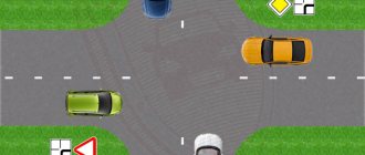
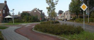
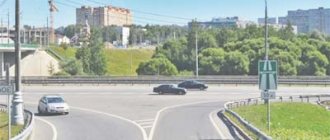
Everything seems simple, let's take a situation that is not uncommon on the highways. A narrower regular road adjoins the highway.
According to the definition of an intersection, a junction of a road is also considered an intersection, and such an intersection fully fits this definition. There is no reason to believe that the wide highway is the main road. Accordingly, this intersection is equivalent and, therefore, before such an intersection the coverage area of the prohibitory sign ends, despite the fact that the driver may simply not physically see this intersection behind the dividing strip, but this intersection exists.
Next, let's try to determine whether the zone at the intersection is interrupted or not based on the next paragraph
The effect of the signs is not interrupted at exit points from areas adjacent to the road and at intersections (junctions) with field, forest and other secondary roads in front of which the corresponding signs are not installed.
Two questions arise here:
- How can a road be a secondary road if there are no signs before the intersection? Indeed, in this case the intersection turns out to be equivalent.
- What signs are appropriate?
The answers to these questions are contained in the definition of “Main Road”:
“Main road” - a road indicated by signs 2.1, 2.3.1 - 2.3.7 or 5.1, in relation to the one being crossed (adjacent), or a road with a hard surface (asphalt and cement concrete, stone materials, etc.) in relation to the dirt road , or any road in relation to exits from adjacent territories. The presence of a paved section on a minor road immediately before the intersection does not make it equal in importance to the one it intersects.
Thus, the coverage area of the signs is not interrupted in the following cases:
- The road being crossed is dirt, field or forest,
- There are no signs 2.1, 2.3.1 - 2.3.7 or 5.1 installed in front of the road being crossed, and the intersection is not equivalent.
Let's take another example in which questions may arise about the coverage area of the signs under discussion.
The situation is familiar to everyone, despite the fact that such an organization of traffic does not comply with the requirements of the road safety law, in practice it is used very often, and is already taught from driving schools - if there are no priority signs in front of the intersection and no matter what the main road seems to you you need to make sure that there is an “inverted” triangle or hexagon on the road you are crossing and only then continue moving, confident in your advantage.
But what do we have in our discussion?
On the one hand, in the direction of travel, there are no signs indicating that the road being crossed is a secondary one and formally for the driver such an intersection is equivalent. A sign with its back side facing the driver, of course, cannot impose any requirements. And since such an intersection is equivalent for the driver, the coverage area of the prohibition signs under discussion ends at such an intersection.
On the other hand, the road actually being crossed is of secondary importance and we know this; also, there are no corresponding signs installed before the intersection and the coverage area of the prohibition signs under discussion does not end at such an intersection.
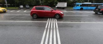
Of course, it would be correct to focus on the first option, but if we take an example as in the first picture, then convincing the traffic police inspector that the sign’s effect has ended at such an intersection will be extremely problematic.
The sign's coverage area may also be reduced.
The coverage area of signs may be reduced:
- for signs 3.16 and 3.26 using a plate;
- for signs 3.20, 3.22, 3.24 by installing signs 3.2, 3.23, 3.25 at the end of their coverage area, respectively, or using plate 8.2.1. The coverage area of sign 3.24 can be reduced by installing sign 3.24 with a different maximum speed value;
- for signs 3.27-3.30 by installing at the end of their validity repeated signs 3.27-3.30 with plate 8.2.3 or using plate 8.2.2. Sign 3.27 can be used in conjunction with marking 1.4, and sign 3.28 with marking 1.10, while the coverage area of the signs is determined by the length of the marking line.
Please note that it is not possible to increase the coverage area of signs using signs, only downwards.
Prohibition zones signs
All prohibition signs have general and individual coverage areas depending on the specific sign, the road situation, other road signs following them in the direction of your movement and some other situations. Many of them provide for a substantial fine or even deprivation of rights for violating their regulations. Therefore, in the article we will carefully study what the coverage area of prohibitory signs is in 2021, what cancels them and what does not cancel them, what are the priorities when combining them with canceling ones, and many other subtleties.
Coverage area of prohibiting road signs
We will not provide long descriptions for each of the signs in this section of the traffic rules, but instead will show in a convenient tabular form a concise explanation of their coverage area depending on the specific traffic situation.
| Sign | What does it look like? | Sign area |
| 3.1 Entry prohibited | This sign extends its effect to the section of the road in front of which it is installed. If it is installed in front of a one-way road, then it is valid until the nearest intersection, if there is no similar sign further (otherwise, if you enter from another road, how will you see that it is a one-way road?!). Installed in all other cases, sign 3.1 is valid throughout the entire territory of roads, the entrances to which are marked with the same sign. | |
| 3.2 No movement |
This sign restricts movement along the section of the road in front of which it is installed, but only if you do not work or live there, and also if you are not disabled group I or II. The sign is valid throughout the entire territory, which similarly cannot be reached from other entrances marked with the same sign.
What signs indicate the extent of the coverage area of the signs with which they are used?
| 1. | Only A. |
| 2. | Only B. |
| 3. | B and V. |
Answer
| The extent of the sign's coverage area is indicated by plate B (Validity area). |
| The extent of the sign's coverage area is indicated by plate B (Prohibition area). |
| Plate A (Distance to object) is used when it is necessary to show the exact distance from the sign to the beginning of a dangerous section, the place where a corresponding restriction is introduced, or a specific object located ahead in the direction of travel. |
The correct answer is B and C.
Description
In accordance with paragraph 13.3 of the traffic rules, there are 2 types of intersections.
Adjustable
They have a traffic light installed and operating in normal mode, and it is responsible for the correct passage of cars. Depending on his signals or the inspector’s instructions, traffic participants stop or resume their movement.
If suddenly the traffic light is faulty, turned off, or “yellow” is constantly flashing, we have an unregulated intersection in front of us. Here, drivers and pedestrians are required to adhere to the existing rules governing passage at intersections of this type and take as a basis the road signs of intersections, which will be discussed a little later.
Unregulated
They are determined by the absence of any regulation, and specifically: the traffic light is not working or has switched to “yellow flashing” mode, there is no traffic controller. In this case, everyone needs to be careful and it is advisable to quickly remember the rules for driving through such intersections.
Road intersections can take various forms:
Quadrilateral in X shape;
three-sided in the shape of the letter T;
three-sided Y-shaped with different adjacent ones and at any angle;
with circular motion.
Area of prohibition signs
Good afternoon, dear car enthusiasts!
In this material we will look in detail at how to determine the coverage area of prohibitory road signs 3.16, 3.20, 3.22, 3.24, 3.26-3.30.
Why these particular signs? The coverage area of prohibition signs is determined by the Traffic Rules, and with its definition for these signs, some questions remain that may not be noticeable at first glance.
So, the Traffic Rules define the coverage area of these signs with the following text:
The coverage area of signs 3.16, 3.20, 3.22, 3.24, 3.26-3.30 extends from the place where the sign is installed to the nearest intersection behind it, and in populated areas, in the absence of an intersection, to the end of the populated area. The effect of the signs is not interrupted at exit points from areas adjacent to the road and at intersections (junctions) with field, forest and other secondary roads, in front of which the corresponding signs are not installed.
The effect of sign 3.24, installed in front of a populated area indicated by sign 5.23.1 or 5.23.2, extends to this sign.
Everything seems simple, let's take a situation that is not uncommon on the highways. A narrower regular road adjoins the highway.
- According to the definition of an intersection, a junction of a road is also considered an intersection, and such an intersection fully fits this definition. There is no reason to believe that the wide highway is the main road. Accordingly, this intersection is equivalent and, therefore, before such an intersection the coverage area of the prohibitory sign ends, despite the fact that the driver may simply not physically see this intersection behind the dividing strip, but this intersection exists.
Next, let's try to determine whether the zone at the intersection is interrupted or not based on the next paragraph
The effect of the signs is not interrupted at exit points from areas adjacent to the road and at intersections (junctions) with field, forest and other secondary roads in front of which the corresponding signs are not installed.
Two questions arise here:
- How can a road be a secondary road if there are no signs before the intersection? Indeed, in this case the intersection turns out to be equivalent.
- What signs are appropriate?
The answers to these questions are contained in the definition of “Main Road”:
“Main road” - a road indicated by signs 2.1, 2.3.1 - 2.3.7 or 5.1, in relation to the one being crossed (adjacent), or a road with a hard surface (asphalt and cement concrete, stone materials, etc.) in relation to the dirt road , or any road in relation to exits from adjacent territories. The presence of a paved section on a minor road immediately before the intersection does not make it equal in importance to the one it intersects.
Thus, the coverage area of the signs is not interrupted in the following cases:
- The road being crossed is dirt, field or forest,
- There are no signs 2.1, 2.3.1 - 2.3.7 or 5.1 installed in front of the road being crossed, and the intersection is not equivalent.
Let's take another example in which questions may arise about the coverage area of the signs under discussion.
The situation is familiar to everyone, despite the fact that such an organization of traffic does not comply with the requirements of the road safety law, in practice it is used very often, and is already taught from driving schools - if there are no priority signs in front of the intersection and no matter what the main road seems to you you need to make sure that there is an “inverted” triangle or hexagon on the road you are crossing and only then continue moving, confident in your advantage.
But what do we have in our discussion?
On the one hand, in the direction of travel, there are no signs indicating that the road being crossed is a secondary one and formally for the driver such an intersection is equivalent. A sign with its back side facing the driver, of course, cannot impose any requirements. And since such an intersection is equivalent for the driver, the coverage area of the prohibition signs under discussion ends at such an intersection.
On the other hand, the road actually being crossed is of secondary importance and we know this; also, there are no corresponding signs installed before the intersection and the coverage area of the prohibition signs under discussion does not end at such an intersection.
Of course, it would be correct to focus on the first option, but if we take an example as in the first picture, then convincing the traffic police inspector that the sign’s effect has ended at such an intersection will be extremely problematic.
The sign's coverage area may also be reduced.
The coverage area of signs may be reduced:
Please note that it is not possible to increase the coverage area of signs using signs, only downwards.
Dear you without obstacles!
.
Explanation
Signs that determine the order of travel at uncontrolled intersections and various intersections (intersection road signs in traffic rules) are classified as priority signs. Basically, they are made in the shape of a triangle with a red rim and at first glance resemble warning signs. Signs indicating priority are placed in advance of intersections; their task is to ensure traffic safety in these areas.
They can be roughly divided into groups.
the main road
Sign 2.1 is “main road”. The driver, seeing this sign, immediately understands that he is a “priority” and can cross the uncontrolled intersection first and not let anyone through. But in any case, he must be extremely careful and slow down, there is a possibility that the other driver may get lost and then a collision cannot be avoided.
Sign 2.2 “end of the main road” - everything is extremely simple with it. Be careful, the advantage is gone.
This sign does not turn the main road into a secondary one, it is simply now an intersection of equivalent roads.
minor road
2.3.1 “Intersection with a secondary road” and 2.3.2 - 2.3.7 “Junction with a secondary road” are similar in meaning and carry information that two roads intersect in front of you: the main one with the secondary one.
It can adjoin the road surface at any angle. These road signs are usually installed outside the city, outside populated areas; they indicate to the motorist that there is an advantage over those on a secondary road.
2.4 “Give way” and 2.5 “Driving without stopping is prohibited” inform the driver that he is on an adjacent secondary road and must wait and let everyone on the main road pass.
When leaving a residential yard or an adjacent area, even if sign 2.4 is missing, give way!
Equivalent intersection
This is the intersection of roads of equal importance.
These signs warn you:
| 1. | About the presence of dangerous turns after 500 m. |
| 2. | That at a distance of 150-300 m behind the road sign a 500 m long section of road with dangerous turns will begin. |
| 3. | That immediately after the sign a 500 m long section with dangerous turns will begin. |
The dangerous turns sign warns you that in 150 - 300 m a section of the road will begin with several dangerous turns following each other, the first of which is to the left. The “Area of Action” sign specifies that the total length of this section is 500 m.
Fines
Failure to comply with the rules for driving through intersections entails the imposition of administrative penalties. A detailed table of fines can be found here.
Based on clause 12.12 part 1, for driving through a red traffic light or a traffic controller's prohibitory sign, the driver is charged a fine of 1,000 rubles.
In the event that the driver of the vehicle does not allow a car to pass, which has the right of way through the intersection, in accordance with clause 12.13, part 2, the fine is 1000 rubles.
Systematic failure to comply with the requirements of traffic rules and repeated violations can lead to more serious consequences: a fine of 5,000 rubles or deprivation of a driver’s license for a period of 4 to 6 months (clause 12.12, part 3).