Traffic rules of the Republic of Belarus 2021
The Traffic Rules given in this section are the current Traffic Rules of the Republic of Belarus 2021, improved with hyperlinks and pop-up help windows (changes and additions to Decree No. 349 of the President of the Republic of Belarus dated August 10, 2015 and subsequent decrees are taken into account).
The source of information is the National Register of Legal Acts of the Republic of Belarus. Reference data bank of legal information of the Republic of Belarus.
The Traffic Rules highlight special active elements . The active element of the text in the traffic rules of the Republic of Belarus is an indication in the text of the Rules to another paragraph of the Rules, to the number of the road sign or to a term and other instructions. The graphical active element in the traffic rules is all images of road signs and road markings, as well as images of road traffic lights.
In the Traffic Regulations of the Republic of Belarus, a hint window and a hyperlink are attached to the active element.
The traffic rules of the Republic of Belarus contain implicit terms. Such an implicit term of the traffic rules, for example, is the term “Congestion”, and its definition: “Congestion is a cluster of other vehicles stopped on the roadway” is obvious from clause 53.2 of the traffic rules:
"53.2. when a vehicle is forced to stop on the roadway and in places where stopping is prohibited, with the exception of stopping the movement of the vehicle due to the accumulation of other vehicles stopped on the roadway (hereinafter referred to as a traffic jam).”
Note that additional emphasis on implicit terms allows you to better understand the Rules of the Road! We found about 20 such implicit terms in the traffic rules of the Republic of Belarus.
Interactivity in the online traffic rules of the Republic of Belarus is ensured as follows:
- When the mouse cursor hits an active element of the traffic rules text, a pop-up window appears with the corresponding additional information. In paper version, such information often has to be looked for by turning page by page of a traffic rules book;
- when the mouse cursor hits a graphical active element (road sign, markings, traffic light), a pop-up window appears with the corresponding additional information on this graphic element of the Traffic Rules;
- following a link from any active element of the traffic rules text to the corresponding electronic page of the Traffic Rules.
Pop-up help windows may also use implicit traffic rules terms, various traffic rules groupings and creative traffic rules memos.
Closely related to the Belarus traffic rules section is another section of the website “Road Rules 2020” - Express tests. Express tests are a new type of testing according to the Belarusian Traffic Rules. This type of testing covers all points of the traffic rules and tests the test taker for accurate knowledge of the important requirements of the Rules. At the same time, express tests for traffic rules are quick tests that do not take much time during the testing process. Express tests are quick and easy. A quick question in electronic form is a high-tech, informative and educational question. Compared to classic traffic rules testing of the form “Question - Illustration (if any) - Answer options", express testing is an alternative test and has its advantages.
Select below what interests you in “Traffic Regulations Belarus” now: chapters of the Rules, appendices to the Rules, decrees of the President of the Republic of Belarus:
Expand all Decrees of the President of the Republic of Belarus in the section “Traffic Rules Belarus”
Expand all Chapters of Traffic Regulations (27 chapters) in the section “Traffic Regulations Belarus”
Expand Appendix 1 “Road traffic lights” in the section “Traffic rules Belarus”
Expand all chapters and paragraphs of Appendix 2 “Road Signs” (2 chapters, 7 paragraphs in each chapter) in the “Traffic Rules for Belarus” section
Expand all chapters of Appendix 3 “Road markings” (3 chapters) in the “Traffic rules for Belarus” section
Expand all chapters of Appendix 4 “List of vehicle malfunctions” (7 chapters) in the “Traffic Rules for Belarus” section
Expand Appendix 5 “Vehicle identification marks” in the “Traffic rules for Belarus” section
Go to the Express tests section of the site.
A little information on the traffic rules of the Republic of Belarus:
There are not enough illustrations in the decrees of the President of the Republic of Belarus on traffic rules. In 2009, a scientific and practical publication appeared - a commentary on the Traffic Rules, 560 pages in size with black and white illustrations.
The commentary to the Traffic Rules does not currently reflect the important changes made to the Traffic Rules by Decree of the President of the Republic of Belarus dated October 13, 2014 No. 483 “On Amendments and Additions to the Traffic Rules.”
so UNT / Traffic rules / Lesson plans for traffic rules 6th grade
Lesson No. 8 Topic: “Road markings and their characteristics”
26.09.2013 25847 0
Goals and objectives of the lesson:
familiarizing students with types of road markings; developing skills in reading and using road markings when driving.
Materials for the lesson:
Road markings
– a means of organizing traffic, which consists of lines, inscriptions and other designations of which are applied to various elements of roads and road structures. Markings can be used independently, as well as in combination with other means of traffic regulation - road signs and traffic lights. There are two types of markings: horizontal, which is applied directly to the roadway or along the top of the curb, and vertical, which is applied to the vertical surfaces of bridge supports, overpasses and other structures, as well as on elements of road equipment. In this case, the markings are made in the form of black and white alternating stripes.
It is important for a pedestrian to be able to identify road markings indicating that in a given specific place it is possible to cross the roadway, i.e. pedestrian crossings:
– unregulated zebra crossing. In the absence of zebra markings, the width of the pedestrian crossing is determined by the distance between the pedestrian crossing signs installed at different levels on opposite sides of the roadway;
– a controlled pedestrian crossing, where traffic is regulated by a traffic light, and the pedestrian must be guided by the signals of the traffic controller or traffic light. If the traffic light signals contradict the signals of the traffic controller, then the pedestrian is obliged to comply with the requirements of the traffic controller.
Road markings on the roadway also tell pedestrians how they are allowed to cross the road:
– if there is a solid dividing line on the roadway and there is no marked pedestrian crossing nearby either to the left or to the right in the visibility zone, then the pedestrian has the right to cross the road in the absence of a pedestrian crossing, having first made sure of a good view (clearly visible in both directions) in that place , where I decided to cross it at right angles to the edge of the roadway. A pedestrian who does not have time to complete the crossing may stop on the dividing line;
– if there is a dividing strip on the roadway, a structurally designated element of the road (lawn, green spaces, fenced strip, etc.) separating adjacent roadways, then a pedestrian must not cross the road outside the pedestrian crossing zone. A pedestrian must find a section on such a road where a pedestrian crossing is marked and cross the roadway at this point. Both pedestrians and drivers are prohibited from moving or stopping on the median strip.
Vertical markings are designed to prevent vehicles from colliding with bridge supports, overhangs, curbs and other elements of road structures.
ROAD MARKINGS AND ITS CHARACTERISTICS
Horizontal markings (lines, arrows, inscriptions and other markings on the roadway) establish certain modes and order of movement.
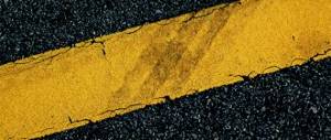
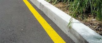
Horizontal markings can be permanent or temporary. Permanent markings are white, except for lines 1.4, 1.10 and 1.17, yellow; temporary markings are orange.
1. Horizontal marking:
1.1 – separates traffic flows in opposite directions and marks the boundaries of traffic lanes in dangerous places on the roads; indicates the boundaries of the roadway to which entry is prohibited; marks the boundaries of vehicle parking spaces;
1.2.1. (solid line) – indicates the edge of the roadway;
1.2.2. (dashed line, the length of the strokes is 2 times shorter than the spaces between them) - indicates the edge of the roadway on two-lane roads;
1.3 – separates traffic flows in opposite directions on roads with four lanes or more;
1.4 – indicates places where stopping is prohibited. It is used alone or in combination with sign 3.27 and is applied at the edge of the roadway or along the top of the curb;
1.5 – separates traffic flows in opposite directions on roads with two or three lanes; indicates the boundaries of traffic lanes when there are two or more lanes intended for traffic in the same direction;
1.6 (approach line - a broken line in which the length of the strokes is 3 times greater than the spaces between them) - warns of approaching markings 1.1 or 1.11, which separate traffic flows in opposite or similar directions;
1.7 (dashed line with short strokes and equal intervals) – indicates traffic lanes within the intersection;
1.8 (wide broken line) – marks the boundary between the acceleration or deceleration lane and the main lane of the roadway (at intersections, road crossings at different levels, in the area of bus stops, etc.);
1.9 - indicates the boundaries of the lanes on which reverse control is carried out; separates traffic flows of opposite directions (with reverse traffic lights turned off) on roads where reverse control is carried out;
1.10 - indicates places where parking is prohibited. It is used alone or in combination with sign 3.28 and is applied at the edge of the roadway or along the top of the curb;
1.11 - separates traffic flows of opposite or similar directions on road sections where changing lanes is allowed only from one lane; indicates places designated for turning,
The marking numbering corresponds to GOST R51256-99. 38 exiting and exiting parking areas, etc., where traffic is allowed only in one direction;
1.12 (stop line) – indicates the place where the driver must stop in the presence of sign 2.5 or when there is a prohibiting traffic light signal (traffic controller);
1.13 – indicates the place where the driver must, if necessary, stop, giving way to vehicles moving along the road being crossed;
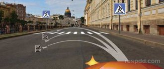
1.14.1, 1.14.2 (“zebra”) – denotes a pedestrian crossing; arrow markings 1.14.2 indicate the direction of movement of pedestrians;
1.15 - indicates the place where the bicycle path crosses the roadway;
1.16.1–1.16.3 – denotes guide islands in places where traffic flows separate or merge;
1.17 – denotes bus stops and taxi ranks;
1.18 – indicates the lane directions allowed at the intersection. Used alone or in combination with signs 5.8.1, 5.8.2; markings with the image of a dead end are applied to indicate that turning onto the nearest roadway is prohibited; markings permitting a left turn from the leftmost lane also permit a U-turn;
1.19 - warns of approaching a narrowing of the roadway (a section where the number of lanes in a given direction is reduced) or marking lines 1.1 or 1.11, separating traffic flows in opposite directions. In the first case, marking 1.19 can be used in combination with signs 1.18.1 - 1.18.3;
1.20 – warns of approaching marking 1.13;
1.21 (sign “STOP”) – warns of approaching marking 1.12 when it is used in combination with sign 2.5;
1.2.2 – indicates the road (route) number;
1.23 – designates a special lane for route vehicles.
1.24.1–1.24.3 – duplicates the corresponding road signs and is used in conjunction with them;
1.25 – indicates an artificial bump on the roadway.
Lines 1.1, 1.2.1 and 1.3 are prohibited from crossing.
It is allowed to cross line 1.2.1, which marks the edge of the roadway and is located to the right of the driver, to stop the vehicle on the side of the road.
Lines 1.2.2, 1.5 - 1.8 are allowed to be crossed from any side.
Line 1.9, in the absence of reversible traffic lights or when they are turned off, is allowed to be crossed if it is located to the right of the driver with the reversible traffic lights on - on either side, if it separates lanes along which traffic is allowed in one direction. When the reversing traffic lights are turned off, the driver must immediately change lanes to the right beyond marking line 1.9.
Line 1.9, separating traffic flows in opposite directions, is prohibited from crossing when the reversible traffic lights are turned off.
Line 1.11 is allowed to be crossed from the broken side, as well as from the solid side, but only upon completion of overtaking or detour.
In cases where the meanings of temporary road signs placed on a portable post and marking lines contradict each other, drivers must be guided by the signs.
In cases where temporary marking lines and permanent marking lines contradict each other, drivers must be guided by the temporary marking lines.
In populated areas, horizontal markings are used on expressways and main streets, as well as on other roads along which public passenger transport routes pass. Outside populated areas, markings are used on roads with a carriageway width of 6 m or more with a traffic intensity of 1000 or more vehicles per day.
In other cases, horizontal markings are applied if necessary to ensure road safety.
All longitudinal marking lines, except lines 1.2 and 1.8, have a width of 0.1 m (the same width is the gap between marking lines 1.3, 1.9 and 1.11). Marking 1.2 has a width of 0.2 m, and line 1.8 can be 0.4 m wide if it is used to separate acceleration or braking lanes at intersections and junctions of roads, and 0.2 m in other cases (in the area of bus stops, at gas stations, etc.).
Transverse markings include lines 1.12-1.14. Marking 1.12 (stop line) has a width of 0.4 m, marking 1.13 is formed from isosceles triangles with a base of 0.5 m and a height of 0.9 m, pedestrian crossing markings 1.14.1 and 1,14,2 are stripes with a width of 0 .4 m with intervals between them of 0.6 m (marking 1.14.2 is supplemented with guide arrows to streamline the movement of pedestrians on wide crossings).
The width of the marked pedestrian crossing is set taking into account the intensity of traffic during peak hours at the rate of 1 m for every 500 pedestrians per hour, but not less than 4 m. If the width of the crossing is more than 6 m, then markings of type 1.14.2 are used.
Other types of horizontal markings include markings 1.15-1.23.
Crossing for cyclists 1.15 is indicated by squares measuring 0.4x0.4 m (crossing width is at least 1.8 m). Islands 1.16, used to separate traffic flows, are an area limited by markings 1.1, with wide stripes applied at a certain angle (for better visibility of the island).
Marking 1.17 is applied in lines 0.1 m wide and is used mainly in populated areas to mark stops for route buses, trolleybuses or taxis. The width of the strip on which such markings are applied is 2 m.
In the area marked with marking 1.17, other vehicles are allowed to stop if this does not interfere with the movement of a shuttle bus, trolleybus or taxi cars. Arrows 1.18 and 1.19 on sections of roads where traffic is allowed at a speed of no more than 60 km/h have a length of 3 m, and on sections with a higher permitted speed - 6 m.
Arrow 1.18, indicating a left turn and placed on the leftmost lane, in the absence of the sign 3.19 “No U-turn”, also allows a U-turn.
Marking 1.18 with the image of a dead end is applied before the intersection of roads with several carriageways, when turning onto the nearest carriageway is prohibited.
The approach triangle K20 has a base of 1.6 m and a height of 4 m and is applied at a distance from 2 to 25 m to line 1.13 (in shape, marking 1.20 resembles sign 2.4 “Give way” and serves as an additional means of warning about approaching marking 1.13).
Marking 1.21 (inscription “STOP”) has a letter height of 1.6 m with a total width of the entire inscription of 2.32 m and is applied at a distance from 2 to 25 m to the stop lines only if there is a sign 2.5 “No stopping without stopping” in front of the intersection.
Marking 1.22 (road number) is applied on the traffic lane. The height of numbers and letters on road sections at a permitted speed of up to 60 km/h is 1.6 m, and at higher speeds - 4 m. The letter “E” means that this road belongs to the system of European roads open to international traffic.
Marking 1.23 (the width of the base of the letter “A” is 1.4 m, the height is 3 m) is applied so that the base of the letter “A” is facing towards vehicles moving along this lane. This marking is applied in the presence of sign 5.9. Using these markings, acceleration and deceleration lanes can be designated before stopping for public vehicles moving along established routes,
It is prohibited to cross lines 1.1 and 1.3, except when line 1.1 is used to mark the edge of the roadway.
Solid lines of longitudinal markings are applied in areas where it is necessary to prohibit maneuvering (on curves of small radii, with limited visibility, in front of the tops of slopes, on approaches to intersections, railway crossings, etc.). Therefore, crossing continuous lines of longitudinal markings or even running into them is prohibited. The exception is when line 1.1 is used to mark the edge of the roadway. In this case, you can cross it for a subsequent stop,
Markings can be used to mark out areas on the roadway where traffic is prohibited. These could be, for example, landing areas at tram stops, islands or “reserve zones” separating traffic flows, etc.
Lines 1.2, 1.5-1.8 are allowed to be crossed from any side. Line 1.9 is allowed to be crossed if it is located to the right of the driver. Line 1.11 is allowed to be crossed only from the side of the broken line.
Intermittent single lines of longitudinal markings are used to separate oncoming traffic flows and highlight traffic lanes. The broken center line is applied mainly in areas with good visibility, where overtaking is not prohibited. Crossing broken single lines is allowed. However, if lanes are marked with such lines, then drivers should stick to the middle of the lane and not unnecessarily. drive over the marking line.
Broken double lines of longitudinal markings 1.9 are used to highlight lanes where the direction of movement can change to the opposite.
Line 1.9 in the absence of reversible traffic lights or when they are turned off is allowed to be crossed if it is located to the right of the driver; when reverse traffic lights are on - on any side, if it separates lanes on which traffic is allowed in one direction. When the reversing traffic lights are turned off, the driver must immediately change lanes to the right beyond marking line 1.9. Line 1.9, separating traffic flows in opposite directions, is prohibited from crossing when the reversible traffic lights are turned off. Line 1.9, separating traffic flows in opposite directions, is prohibited from crossing when the reversible traffic lights are turned off. Marking 1.9 is allowed to be crossed only if it is located to the right of the driver.
Line 1.11 is used to limit maneuvering, usually in areas with limited visibility. You can cross it only from the side of the broken line when performing any maneuvers, and from the side of the solid line only when completing overtaking that you started earlier. If line 1.11 is used to separate lanes in the same direction, and not as a center line, then it can only be crossed from the side of the broken line to change lanes into the adjacent lane.
Inscriptions and other markings may be placed on the roadway to help drivers navigate the situation, but without introducing any restrictions.
In some cases, in order to provide drivers with more complete information about traffic patterns, the names of route points may be marked on the roadway (in addition to markings 1.17). For example, the words “taxi” and “bus” may be written on the roadway. Other inscriptions or symbols that are understandable to drivers (for example, images of road signs) may also be used.
In cases where the meanings of road signs and marking lines contradict each other, drivers must be guided by the signs.
This situation can arise, as a rule, in cases where there is a need to temporarily change the existing traffic organization scheme (for example, during mass events, folk festivals). Drivers must follow temporary signs (installed on posts), even if their requirements contradict the requirements of road markings.
Vertical markings.
Vertical markings in the form of a combination of black and white stripes on road structures and elements of road equipment show their dimensions and serve as a means of visual orientation.
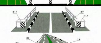
2.1.1-2.1.3 – designate elements of road structures (bridge supports, overpasses, end parts of parapets, etc.), when these elements pose a danger to moving vehicles;
2.2 – indicates the lower edge of the superstructure of tunnels, bridges and overpasses;
2.3 – denotes round bollards installed on dividing strips or traffic islands;
2.4 - denotes guide posts, grooves, fence supports, etc.;
2.5 – designates the side surfaces of road fences on small radius curves, steep slopes, and other dangerous areas;
2.6 – indicates the side surfaces of road fences in other areas;
2.7 – denotes curbs in dangerous areas and raised traffic islands.
As already noted, combinations of black and white are used for vertical markings. Black and white marking stripes 2.1 are applied at an angle of 45° to the vertical so that their inclination is directed towards the roadway. If the vertical surface is large, only the edge closest to the roadway is marked to a width of 0.5 m, and if the height is large, to a height of 2 m.
Using vertical markings
Marking 2.2 is used when the vertical dimension of an artificial structure is less than 5 m and is applied above the middle of each traffic lane.
If it is impossible to apply markings 2.1 and 2.2 on the surface of the structure, it is carried out on boards attached to the elements of the span or installed in front of them.
Alternating black and white marking stripes 2.3 are used to indicate only bollards or beacons installed on traffic islands in places where traffic flows separate or merge.
Using marking 2.4 in the form of an inclined stripe on a white background, various posts, gouges, fence supports, as well as trees growing close to the roadway are indicated. The black stripe, drawn at an angle of 60° to the vertical, is inclined towards the roadway.
Marking 2.5 is a combination of sections painted black and white (the length of the white section is 2 m, the length of the black section is 1 m).
Marking 2.6 is made in the form of a black horizontal stripe 0.1 m wide on a white background of the side surfaces of road barriers.
Curb stones and side surfaces of islands in areas of increased danger are painted black and white with a ratio of the length of the white to black section of 2:1.
Vertical markings do not introduce any restrictions on traffic and serve as a means of additional information for drivers.
For better visibility, the white vertical marking stripes 2.1-2.3 can be covered with reflective film by 2/3 of their width.
Currently, reflective film is being produced for the production of road signs. This film is made of aluminum foil, onto which a layer of microspheres with a diameter of 40-200 microns with a refractive index of 2.2 is fixed using a special synthetic varnish. This film can be used in combination with vertical markings to improve the visibility of designated elements at night. For the same purpose, retroreflectors (reflectors), similar to those used on vehicles, can be used.
Questions for consolidation:
1. What rules should pedestrians follow when at a public transport stop?
2. You got off the tram, there is no landing area, what should you do in this case?
3. What does the dividing line mean?
4. What is the difference between the purpose of vertical and horizontal markings?
5. What layout would you suggest for a school yard if there was heavy cyclist traffic?
Lecture road markings types and descriptions
Road markings
Road markings
– a means of organizing traffic, which consists of lines, inscriptions and other designations of which are applied to various elements of roads and road structures. Markings can be used independently, as well as in combination with other means of traffic regulation - road signs and traffic lights. There are two types of markings: horizontal, which is applied directly to the roadway or along the top of the curb, and vertical, which is applied to the vertical surfaces of bridge supports, overpasses and other structures, as well as on elements of road equipment. In this case, the markings are made in the form of black and white alternating stripes.
It is important for a pedestrian to be able to identify road markings indicating that in a given specific place it is possible to cross the roadway, i.e. pedestrian crossings:
– unregulated zebra crossing. In the absence of zebra markings, the width of the pedestrian crossing is determined by the distance between the pedestrian crossing signs installed at different levels on opposite sides of the roadway;
– a controlled pedestrian crossing, where traffic is regulated by a traffic light, and the pedestrian must be guided by the signals of the traffic controller or traffic light. If the traffic light signals contradict the signals of the traffic controller, then the pedestrian is obliged to comply with the requirements of the traffic controller.
Road markings on the roadway also tell pedestrians how they are allowed to cross the road:
– if there is a solid dividing line on the roadway and there is no marked pedestrian crossing nearby either to the left or to the right in the visibility zone, then the pedestrian has the right to cross the road in the absence of a pedestrian crossing, having first made sure of a good view (clearly visible in both directions) in that place , where I decided to cross it at right angles to the edge of the roadway. A pedestrian who does not have time to complete the crossing may stop on the dividing line;
– if there is a dividing strip on the roadway, a structurally designated element of the road (lawn, green spaces, fenced strip, etc.) separating adjacent roadways, then a pedestrian must not cross the road outside the pedestrian crossing zone. A pedestrian must find a section on such a road where a pedestrian crossing is marked and cross the roadway at this point. Both pedestrians and drivers are prohibited from moving or stopping on the median strip.
Vertical markings are designed to prevent vehicles from colliding with bridge supports, overhangs, curbs and other elements of road structures.
ROAD MARKINGS AND ITS CHARACTERISTICS
Horizontal markings (lines, arrows, inscriptions and other markings on the roadway) establish certain modes and order of movement.
Horizontal markings can be permanent or temporary. Permanent markings are white, except for lines 1.4, 1.10 and 1.17, yellow; temporary markings are orange.
1. Horizontal marking:
1.1 – separates traffic flows in opposite directions and marks the boundaries of traffic lanes in dangerous places on the roads; indicates the boundaries of the roadway to which entry is prohibited; marks the boundaries of vehicle parking spaces;
1.2.1. (solid line) – indicates the edge of the roadway;
1.2.2. (dashed line, the length of the strokes is 2 times shorter than the spaces between them) - indicates the edge of the roadway on two-lane roads;
1.3 – separates traffic flows in opposite directions on roads with four lanes or more;
1.4 – indicates places where stopping is prohibited. It is used alone or in combination with sign 3.27 and is applied at the edge of the roadway or along the top of the curb;
1.5 – separates traffic flows in opposite directions on roads with two or three lanes; indicates the boundaries of traffic lanes when there are two or more lanes intended for traffic in the same direction;
1.6 (approach line - a broken line in which the length of the strokes is 3 times greater than the spaces between them) - warns of approaching markings 1.1 or 1.11, which separate traffic flows in opposite or similar directions;
1.7 (dashed line with short strokes and equal intervals) – indicates traffic lanes within the intersection;
1.8 (wide broken line) – marks the boundary between the acceleration or deceleration lane and the main lane of the roadway (at intersections, road crossings at different levels, in the area of bus stops, etc.);
1.9 - indicates the boundaries of the lanes on which reverse control is carried out; separates traffic flows of opposite directions (with reverse traffic lights turned off) on roads where reverse control is carried out;
1.10 - indicates places where parking is prohibited. It is used alone or in combination with sign 3.28 and is applied at the edge of the roadway or along the top of the curb;
1.11 - separates traffic flows of opposite or similar directions on road sections where changing lanes is allowed only from one lane; indicates places designated for turning,
The marking numbering corresponds to GOST R51256-99. 38 exiting and exiting parking areas, etc., where traffic is allowed only in one direction;
1.12 (stop line) – indicates the place where the driver must stop in the presence of sign 2.5 or when there is a prohibiting traffic light signal (traffic controller);
1.13 – indicates the place where the driver must, if necessary, stop, giving way to vehicles moving along the road being crossed;
1.14.1, 1.14.2 (“zebra”) – denotes a pedestrian crossing; arrow markings 1.14.2 indicate the direction of movement of pedestrians;
1.15 - indicates the place where the bicycle path crosses the roadway;
1.16.1–1.16.3 – denotes guide islands in places where traffic flows separate or merge;
1.17 – denotes bus stops and taxi ranks;
1.18 – indicates the lane directions allowed at the intersection. Used alone or in combination with signs 5.8.1, 5.8.2; markings with the image of a dead end are applied to indicate that turning onto the nearest roadway is prohibited; markings permitting a left turn from the leftmost lane also permit a U-turn;
1.19 - warns of approaching a narrowing of the roadway (a section where the number of lanes in a given direction is reduced) or marking lines 1.1 or 1.11, separating traffic flows in opposite directions. In the first case, marking 1.19 can be used in combination with signs 1.18.1 - 1.18.3;
1.20 – warns of approaching marking 1.13;
1.21 (sign “STOP”) – warns of approaching marking 1.12 when it is used in combination with sign 2.5;
1.2.2 – indicates the road (route) number;
1.23 – designates a special lane for route vehicles.
1.24.1–1.24.3 – duplicates the corresponding road signs and is used in conjunction with them;
1.25 – indicates an artificial bump on the roadway.
Lines 1.1, 1.2.1 and 1.3 are prohibited from crossing.
It is allowed to cross line 1.2.1, which marks the edge of the roadway and is located to the right of the driver, to stop the vehicle on the side of the road.
Lines 1.2.2, 1.5 - 1.8 are allowed to be crossed from any side.
Line 1.9, in the absence of reversible traffic lights or when they are turned off, is allowed to be crossed if it is located to the right of the driver with the reversible traffic lights on - on either side, if it separates lanes along which traffic is allowed in one direction. When the reversing traffic lights are turned off, the driver must immediately change lanes to the right beyond marking line 1.9.
Line 1.9, separating traffic flows in opposite directions, is prohibited from crossing when the reversible traffic lights are turned off.
Line 1.11 is allowed to be crossed from the broken side, as well as from the solid side, but only upon completion of overtaking or detour.
In cases where the meanings of temporary road signs placed on a portable post and marking lines contradict each other, drivers must be guided by the signs.
In cases where temporary marking lines and permanent marking lines contradict each other, drivers must be guided by the temporary marking lines.
In populated areas, horizontal markings are used on expressways and main streets, as well as on other roads along which public passenger transport routes pass. Outside populated areas, markings are used on roads with a carriageway width of 6 m or more with a traffic intensity of 1000 or more vehicles per day.
In other cases, horizontal markings are applied if necessary to ensure road safety.
All longitudinal marking lines, except lines 1.2 and 1.8, have a width of 0.1 m (the same width is the gap between marking lines 1.3, 1.9 and 1.11). Marking 1.2 has a width of 0.2 m, and line 1.8 can be 0.4 m wide if it is used to separate acceleration or braking lanes at intersections and junctions of roads, and 0.2 m in other cases (in the area of bus stops, at gas stations, etc.).
Transverse markings include lines 1.12-1.14. Marking 1.12 (stop line) has a width of 0.4 m, marking 1.13 is formed from isosceles triangles with a base of 0.5 m and a height of 0.9 m, pedestrian crossing markings 1.14.1 and 1,14,2 are stripes with a width of 0 .4 m with intervals between them of 0.6 m (marking 1.14.2 is supplemented with guide arrows to streamline the movement of pedestrians on wide crossings).
The width of the marked pedestrian crossing is set taking into account the intensity of traffic during peak hours at the rate of 1 m for every 500 pedestrians per hour, but not less than 4 m. If the width of the crossing is more than 6 m, then markings of type 1.14.2 are used.
Other types of horizontal markings include markings 1.15-1.23.
Crossing for cyclists 1.15 is indicated by squares measuring 0.4x0.4 m (crossing width is at least 1.8 m). Islands 1.16, used to separate traffic flows, are an area limited by markings 1.1, with wide stripes applied at a certain angle (for better visibility of the island).
Marking 1.17 is applied in lines 0.1 m wide and is used mainly in populated areas to mark stops for route buses, trolleybuses or taxis. The width of the strip on which such markings are applied is 2 m.
In the area marked with marking 1.17, other vehicles are allowed to stop if this does not interfere with the movement of a shuttle bus, trolleybus or taxi cars. Arrows 1.18 and 1.19 on sections of roads where traffic is allowed at a speed of no more than 60 km/h have a length of 3 m, and on sections with a higher permitted speed - 6 m.
Arrow 1.18, indicating a left turn and placed on the leftmost lane, in the absence of the sign 3.19 “No U-turn”, also allows a U-turn.
Marking 1.18 with the image of a dead end is applied before the intersection of roads with several carriageways, when turning onto the nearest carriageway is prohibited.
The approach triangle K20 has a base of 1.6 m and a height of 4 m and is applied at a distance from 2 to 25 m to line 1.13 (in shape, marking 1.20 resembles sign 2.4 “Give way” and serves as an additional means of warning about approaching marking 1.13).
Marking 1.21 (inscription “STOP”) has a letter height of 1.6 m with a total width of the entire inscription of 2.32 m and is applied at a distance from 2 to 25 m to the stop lines only if there is a sign 2.5 “No stopping without stopping” in front of the intersection.
Marking 1.22 (road number) is applied on the traffic lane. The height of numbers and letters on road sections at a permitted speed of up to 60 km/h is 1.6 m, and at higher speeds - 4 m. The letter “E” means that this road belongs to the system of European roads open to international traffic.
Marking 1.23 (the width of the base of the letter “A” is 1.4 m, the height is 3 m) is applied so that the base of the letter “A” is facing towards vehicles moving along this lane. This marking is applied in the presence of sign 5.9. Using these markings, acceleration and deceleration lanes can be designated before stopping for public vehicles moving along established routes,
It is prohibited to cross lines 1.1 and 1.3, except when line 1.1 is used to mark the edge of the roadway.
Solid lines of longitudinal markings are applied in areas where it is necessary to prohibit maneuvering (on curves of small radii, with limited visibility, in front of the tops of slopes, on approaches to intersections, railway crossings, etc.). Therefore, crossing continuous lines of longitudinal markings or even running into them is prohibited. The exception is when line 1.1 is used to mark the edge of the roadway. In this case, you can cross it for a subsequent stop,
Markings can be used to mark out areas on the roadway where traffic is prohibited. These could be, for example, landing areas at tram stops, islands or “reserve zones” separating traffic flows, etc.
Lines 1.2, 1.5-1.8 are allowed to be crossed from any side. Line 1.9 is allowed to be crossed if it is located to the right of the driver. Line 1.11 is allowed to be crossed only from the side of the broken line.
Intermittent single lines of longitudinal markings are used to separate oncoming traffic flows and highlight traffic lanes. The broken center line is applied mainly in areas with good visibility, where overtaking is not prohibited. Crossing broken single lines is allowed. However, if lanes are marked with such lines, then drivers should stick to the middle of the lane and not unnecessarily. drive over the marking line.
Broken double lines of longitudinal markings 1.9 are used to highlight lanes where the direction of movement can change to the opposite.
Line 1.9 in the absence of reversible traffic lights or when they are turned off is allowed to be crossed if it is located to the right of the driver; when reverse traffic lights are on - on any side, if it separates lanes on which traffic is allowed in one direction. When the reversing traffic lights are turned off, the driver must immediately change lanes to the right beyond marking line 1.9. Line 1.9, separating traffic flows in opposite directions, is prohibited from crossing when the reversible traffic lights are turned off. Line 1.9, separating traffic flows in opposite directions, is prohibited from crossing when the reversible traffic lights are turned off. Marking 1.9 is allowed to be crossed only if it is located to the right of the driver.
Line 1.11 is used to limit maneuvering, usually in areas with limited visibility. You can cross it only from the side of the broken line when performing any maneuvers, and from the side of the solid line only when completing overtaking that you started earlier. If line 1.11 is used to separate lanes in the same direction, and not as a center line, then it can only be crossed from the side of the broken line to change lanes into the adjacent lane.
Inscriptions and other markings may be placed on the roadway to help drivers navigate the situation, but without introducing any restrictions.
In some cases, in order to provide drivers with more complete information about traffic patterns, the names of route points may be marked on the roadway (in addition to markings 1.17). For example, the words “taxi” and “bus” may be written on the roadway. Other inscriptions or symbols that are understandable to drivers (for example, images of road signs) may also be used.
In cases where the meanings of road signs and marking lines contradict each other, drivers must be guided by the signs.
This situation can arise, as a rule, in cases where there is a need to temporarily change the existing traffic organization scheme (for example, during mass events, folk festivals). Drivers must follow temporary signs (installed on posts), even if their requirements contradict the requirements of road markings.
Vertical markings.
Vertical markings in the form of a combination of black and white stripes on road structures and elements of road equipment show their dimensions and serve as a means of visual orientation.
2.1.1-2.1.3 – designate elements of road structures (bridge supports, overpasses, end parts of parapets, etc.), when these elements pose a danger to moving vehicles;
2.2 – indicates the lower edge of the superstructure of tunnels, bridges and overpasses;
2.3 – denotes round bollards installed on dividing strips or traffic islands;
2.4 - denotes guide posts, grooves, fence supports, etc.;
2.5 – designates the side surfaces of road fences on small radius curves, steep slopes, and other dangerous areas;
2.6 – indicates the side surfaces of road fences in other areas;
2.7 – denotes curbs in dangerous areas and raised traffic islands.
As already noted, combinations of black and white are used for vertical markings. Black and white marking stripes 2.1 are applied at an angle of 45° to the vertical so that their inclination is directed towards the roadway. If the vertical surface is large, only the edge closest to the roadway is marked to a width of 0.5 m, and if the height is large, to a height of 2 m.
Using vertical markings
Marking 2.2 is used when the vertical dimension of an artificial structure is less than 5 m and is applied above the middle of each traffic lane.
If it is impossible to apply markings 2.1 and 2.2 on the surface of the structure, it is carried out on boards attached to the elements of the span or installed in front of them.
Alternating black and white marking stripes 2.3 are used to indicate only bollards or beacons installed on traffic islands in places where traffic flows separate or merge.
Using marking 2.4 in the form of an inclined stripe on a white background, various posts, gouges, fence supports, as well as trees growing close to the roadway are indicated. The black stripe, drawn at an angle of 60° to the vertical, is inclined towards the roadway.
Marking 2.5 is a combination of sections painted black and white (the length of the white section is 2 m, the length of the black section is 1 m).
Marking 2.6 is made in the form of a black horizontal stripe 0.1 m wide on a white background of the side surfaces of road barriers.
Curb stones and side surfaces of islands in areas of increased danger are painted black and white with a ratio of the length of the white to black section of 2:1.
Vertical markings do not introduce any restrictions on traffic and serve as a means of additional information for drivers.
For better visibility, the white vertical marking stripes 2.1-2.3 can be covered with reflective film by 2/3 of their width.
Currently, reflective film is being produced for the production of road signs. This film is made of aluminum foil, onto which a layer of microspheres with a diameter of 40-200 microns with a refractive index of 2.2 is fixed using a special synthetic varnish. This film can be used in combination with vertical markings to improve the visibility of designated elements at night. For the same purpose, retroreflectors (reflectors), similar to those used on vehicles, can be used.
Questions for consolidation:
1. What rules should pedestrians follow when at a public transport stop?
2. You got off the tram, there is no landing area, what should you do in this case?
3. What does the dividing line mean?
4. What is the difference between the purpose of vertical and horizontal markings?
5. What layout would you suggest for a school yard if there was heavy cyclist traffic?